
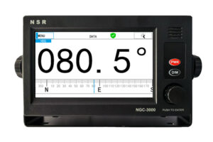

NGC-3000 THD / GNSS
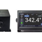
– Determine the heading of a ship
– Highly accurate heading of 0.4° RMS
– Full GNSS with GPS, BDS, GLONASS, GALILEO, QZSS
– Both THD (transmitting heading device) and GNSS (GPS)
– Large LCD, 7-inch/color, touch screen operation
– Highly accurate SOG, COG, ROT and position
– Multi outputs of RS422
– Data interface to BAM/INS
– Up to five display modes available
– Compliant with IMO MSC.116 (73) for THD and IMO
MSC.112 (73) for GNSS (GPS)
– Maintenance-free design
– Type approval with DNV (MED) (for GNSS and
THD) and CCS (for THD)
- Descripción
- Información adicional
- Valoraciones (0)
- SPECIFICATIONS
- Más productos
- Políticas de la tienda
- Consultas
Descripción
– Determine the heading of a ship.
– Highly accurate heading of 0.4° RMS.
– Full GNSS with GPS, BDS, GLONASS, GALILEO, QZSS.
– Both THD (transmitting heading device) and GNSS (GPS).
– Large LCD, 7-inch/color, touch screen operation.
– Highly accurate SOG,COG,ROT and position.
– Multi outputs of RS422 & LAN.
– Data interface to BAM System/INS.
– Up to five display modes available.
– Compliant with IMO MSC.116(73) for THD and IMO MSC.112 (73) for GNSS (GPS).
– Maintenance-free design.
– CCS (THD) type approval.
– DNV (THD/GNSS) type approval.
Información adicional
| Peso | 23 lbs |
|---|---|
| Dimensiones | 12 × 24 × 35 in |
Sé el primero en valorar “NGC-3000 THD / GNSS”
| Model | NGC-3000 |
| GENERAL | |
| Heading Accuracy: | 0.4° RMS |
| Heading Resolution: | 0.1° ~ 0.0001° |
| Tracking rate of turn: | 45°/sec |
| Heading-fixing Time: | Cold start: 60 seconds |
| Pitch/roll angle: | ±60° |
| Receiving frequencies: | GPS L1/L2/L5, BDS B1/B2/B3, GLONASS L1/L2/L3, Galileo E1/E5/E6, QZSS |
| Position Accuracy: | < 2 m |
| Speed Accuracy: | < 0.1 m/s |
| Heading Update Interval: | ≥ 20 ms |
| Position Update Interval: | ≥1 sec |
| Data Output Rate: | max 50Hz |
| DISPLAY SECTION | |
| Display System: | 7 inch, color LCD, touch screen operation, 154(W)×87(H) mm |
| Resolution: | 800 x 480 dots |
| Display Mode: | DATA (Heading, NAV data), PLOTTER, TURN, COMPASS, SATELLITE |
| INTERFACE | |
| Output Data: | 3 x IEC 61162-1/IEC 61162-2 |
| Transmission Speed: | 4800/9600/19200/38400 bps (selectable) |
| BAM/INS In/Out: | ACN, ALC, ALF, HBT |
| Data Sentences: | HDT, THS, ROT, DTM, GBS, GFA, GGA, GLL, GNS, RMC, VTG, ZDA, etc. |
| ENVIRONMENT CONDITION | |
| Temperature Range: | -20℃~+55℃ operational -30℃~+70℃ storage (Antenna Unit) |
| IP Grade: | Antenna Unit: IP66 Processor Unit & Display Unit: IP22 |
| Compass Safe Distance: | Standard Compass: 0.40m, Steering Compass: 0.25m (Display Unit)
Standard Compass: 0.25m, Steering Compass: 0.15m (Processor Unit) |
| Power Supply | DC24V (range 12~36V), 500mA |
| Size | 174 (W) × 81 (H) × 160 (D) mm (Processor Unit) 264 (W) × 145 (H) × 83 (D) mm (Display Unit) 808.2 (W) × 240.1 (H) × 244.4 (D) mm (Antenna Unit) |
Consultas generales
Aún no hay consultas.

Valoraciones
No hay valoraciones aún.